Bakersfield Local Insider
Bakersfield is a city where the old identity (country music, oil rigs, Okie grit) is evolving – making room for something new, exciting, and entirely its own.
DK Law Safe Score Index
Our Safe Roads Index analyzes statewide crash data to highlight the safest — and most dangerous — cities for California drivers.
Bakersfield Traffic Safety Snapshot
A closer look at 2023 collision data and statewide rankings across key safety categories.
TRAFFIC SAFETY OVERVIEW
2,073 traffic fatalities
Ranked 8th worst of 15 cities
California OTS recorded 2,073 people killed or injured in traffic crashes in Bakersfield in 2023, ranking the city 8th among Group A cities (population 250,000+).
pedestrian safety
170 pedestrian fatalities
Ranked 7th worst of 15 cities
170 pedestrians killed or injured in 2023. Between 2018 and 2022, pedestrian fatalities in Bakersfield rose 19.9%, with nighttime crashes concentrated between 6:00 and 8:00 PM in downtown and East Bakersfield.
nighttime crashes
216 nighttime Collisions
Ranked 8th worst of 15 cities
Nighttime collisions (9:00 PM to 2:59 AM) rank mid-pack, but compound the alcohol numbers. Impaired driving after dark is Bakersfield’s deadliest combination.
underage drinking drivers
36 fatalities
Ranked worst of 15 cities
Bakersfield ranks dead last, 1/15, for crashes involving drivers under 21 who had been drinking. The worst in its entire peer group, with no close second.
ALCOHOL-INVOLVED CRASHES
340 fatalities
Ranked 3rd worst of 15 cities
Bakersfield ranks 3/15 for alcohol-involved crash victims killed and injured. Impaired driving is the city’s most severe traffic safety failure by a significant margin.
OVERALL SAFETY INDEX
Composite Safety Score 56.2
Ranked 11th of 21 cities
Bakersfield’s DUI sub-score of 34.6 is the weakest component, reflecting a high proportion of alcohol-involved crashes relative to overall collisions.
Source: California Office of Traffic Safety, Bakersfield 2023 City Rankings · DK Law Traffic Safety Index
Bakersfield offers one of the last paths to California homeownership, a Basque food tradition found nowhere else in the state, and a DK Law Safety Score of 56.2 out of 100, placing the city in the moderate tier for traffic safety.
Bakersfield at a Glance
Bakersfield sits at the southern end of the San Joaquin Valley, roughly two hours north of LA over the Grapevine and a world away from anything coastal California has to offer. With approximately 412,000 residents, it’s one of the largest cities in the state and one of the youngest, with a median age of 31.57, skewed heavily toward working families.
The population is 54.7% Hispanic or Latino, 27.6% White, 8.1% Asian, and 6.1% Black. Median household income sits at $80,783, a number that masks deep racial stratification: Asian households average $112,335 while Black households average $44,322. Only 14.75% of residents hold a bachelor’s degree. The economy runs on oil extraction, agriculture, and logistics, industries that reward showing up, not credentials.
Ask a local what Bakersfield is known for, and you’ll get a stacked answer: oil, country music, farming, and crime. All four are accurate. The city birthed the Bakersfield Sound (Merle Haggard, Buck Owens, Fender Telecasters rejecting Nashville polish), but as of August 2025, the Crystal Palace is dark, Trout’s honky-tonk is being bulldozed for affordable housing, and the Bakersfield Sound lives in museum retrospectives rather than Oildale bars. What replaced it on the ground level is a Tejano dance scene, taco-truck empires, lowrider shows that shut down Wible Road on Friday nights, and night markets that now anchor the weekend social calendar.
Bakersfield works for middle-class families priced out of coastal California who want homeownership, yard space, and short commutes. It works for blue-collar workers in oil, agriculture, and logistics. It works for people who measure quality of life in square footage and community rather than walkability and nightlife density.
Bakersfield is probably not for you if you don’t drive, you’re sensitive to extreme heat (triple digits May through September), or you have respiratory conditions that can’t tolerate the worst air quality in America. The American Lung Association ranked Bakersfield-Delano #1 in the nation for year-round particle pollution in its 2025 report. That’s not a footnote. It’s a daily reality that every prospective resident should weigh.
Bakersfield Highlights
- DK Law Safety Score: 56.2 / 100 (Tier 2: Moderate) – Bakersfield ranks 11th of 21 cities. The DK Law Traffic Safety Index scores cities across three dimensions: crash rate per capita (56.2), impaired driving prevalence (34.6), and vulnerable road user risk (86.7). Alcohol-involved crashes (ranked 3/15 in OTS peer group) and underage drinking drivers (ranked 1/15, the worst in its peer group) are the dominant risk factors. DUI arrests rank 13/15, suggesting significant under-enforcement relative to the scale of the problem.
- Crime Is Real But Geographically Concentrated – Crime rate of 31 per 1,000 residents, with entrenched gang infrastructure on the East Side and South Bakersfield. Kern County homicides dropped to a near-decade low entering 2025, but specific corridors carry concentrated, persistent risk.
- Two Bakersfields, Ten Minutes Apart – Seven Oaks homes start at $650K inside gated country club grounds. East Bakersfield offers the most affordable housing in the city alongside the highest concentration of violent crime. The drive between them is ten minutes and a $500K price gap.
- The Last Affordable Major Metro in California – Median home listing of $423,390 compared to Sacramento ($485K), LA ($943K), and coastal OC ($1.14M+). But rents have risen roughly 40% since the pandemic, and the “cheap” label has eroded to “attainable.”
Is Bakersfield Safe?
Bakersfield’s safety profile is shaped by two distinct problems: violent crime concentrated in specific neighborhoods, and traffic safety failures that rank among the worst in California.
The crime numbers support the city’s reputation, with qualifications. Bakersfield has a crime rate of 31 per 1,000 residents, placing it among the highest in the country for communities of all sizes. The statistical probability of becoming a victim of a violent or property crime is roughly 1 in 32. Kern County’s violent crime rate runs approximately 5.2 per 1,000, comparable to Fresno (4.8) and worse than LA County (4.3).
부당 사망 클레임을 제기할 수 있는 Bakersfield Police Department’s Special Enforcement Unit tracks organizations, including the Eastside Crips, Country Boy Crips, Westside Crips, Lomita Bakers, and Colonia, among others. The territorial boundaries, mapped on a public ArcGIS dashboard, concentrate along the Union Avenue and Cottonwood Road corridors on the East Side and South Bakersfield. Kern County did report homicides dropping to a near-decade low entering 2025. The trajectory is downward. That doesn’t change the fact that specific corridors carry concentrated, persistent risk.
On traffic: the OTS data tells a different but equally concerning story. Bakersfield ranks 3rd worst of 15 peer cities for alcohol-involved crashes (340 victims) and dead last, 1 of 15, for crashes involving underage drinking drivers. Meanwhile, DUI arrests rank just 13/15, meaning the city arrests far fewer impaired drivers than its peers despite having one of the worst impaired-driving crash rates in the state. The gap between the crash numbers and the arrest numbers implies significant under-enforcement.
The Most Dangerous Intersections
- Ming Avenue & New Stine Road: Extreme congestion, high-volume cross-traffic, severe multi-vehicle collisions. One of the most frequently cited crash locations in the city.
- Highway 99 & Route 58 Interchange: High-speed merging collisions affecting regional commuters. The single most dangerous point in Bakersfield’s highway network.
- Union Avenue & California Avenue: High-risk pedestrian corridor with high-speed cross traffic. Tied for the most dangerous intersection in Kern County.
- State Route 43 & Garces Highway: Rural, high-speed severe-injury location just outside the city center. Known for fatal-impact collisions.
Pedestrian fatalities rose 19.9% between 2018 and 2022, reaching 181 deaths over that period. Nighttime pedestrian crashes are overwhelmingly concentrated in downtown and East Bakersfield between 6:00 and 8:00 PM, in areas with poor street lighting and inadequate crosswalk infrastructure.
DK Law represents Bakersfield and Central Valley residents in car accident, pedestrian injury및 wrongful death cases. The intersections listed above (Ming and New Stine, Union and California, the 99/58 interchange) are where those cases concentrate. The alcohol-involved crash data and the DUI enforcement gap make Bakersfield’s roads particularly dangerous.
Best Neighborhoods in Bakersfield
Bakersfield is geographically massive, and the distance between neighborhoods is matched by severe economic segregation. The cardinal rule of Bakersfield real estate: capital, development, and retail density flow west. History, culture, and affordability sit east.
A ten-minute drive here transports you into an entirely different economic reality.
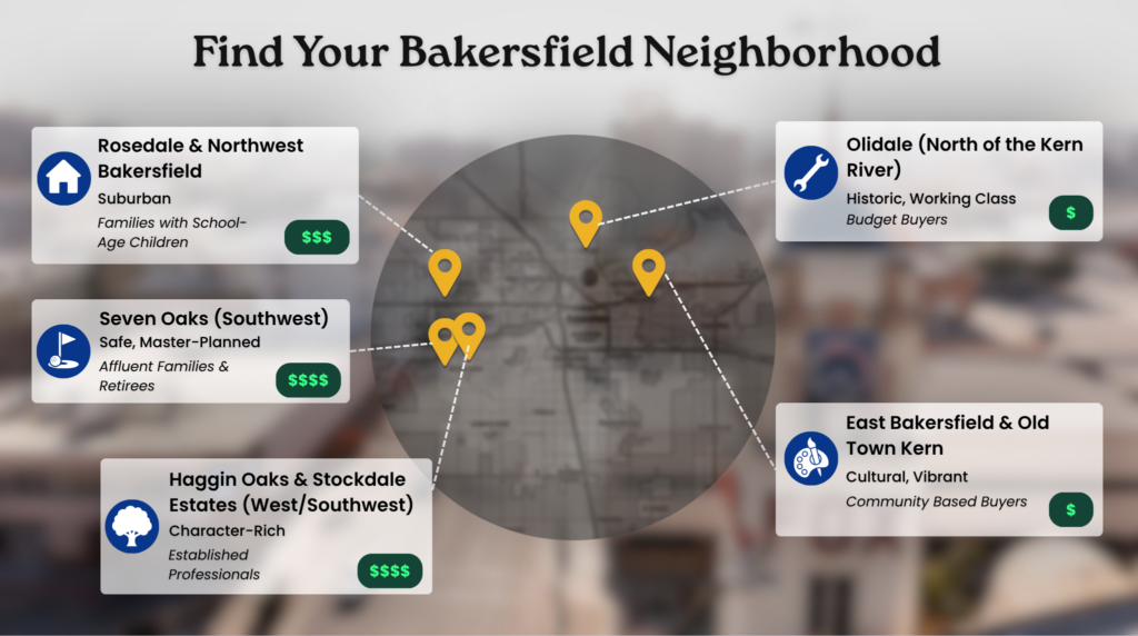
Seven Oaks (Southwest)
The pinnacle of Bakersfield wealth. Master-planned, gated, built around the Seven Oaks Country Club with private parks, manicured streets, and the lowest crime rates in the city. Executives, medical professionals, old oil money, and affluent retirees. Homes average around $650,000 and reach well over $1 million, with rentals starting at $2,500. It functions as an isolated bubble: safe, quiet, and disconnected from the rest of the city in ways that are both the appeal and the limitation.
Best for: Affluent families and retirees who prioritize physical safety and don’t need proximity to the city’s cultural life.
Haggin Oaks & Stockdale Estates (West/Southwest)
Established, older luxury. Unlike the newer cookie-cutter builds farther west, these neighborhoods feature custom-architecture homes on large lots with mature trees and landscaping that takes decades to develop. Generational Bakersfield families, established professionals. Homes range from $600,000 to $900,000. Safety is exceptionally high. The distinction from Seven Oaks is character over curation. These homes have personality.
Best for: Buyers who want west-side safety and schools with homes that don’t look like everything else on the street.
Rosedale & Northwest Bakersfield
The family suburban epicenter. Tract homes, wide streets, big retail plazas, and the city’s most coveted school district. Families buy here specifically for Norris School District zoning, the most desired K-8 district in Bakersfield, with schools consistently ranking in the highest percentiles. Homes average around $400,000. Rentals run $1,800 to $2,200. Upper-middle-class families, local business owners, and commuters.
Best for: Families with school-age children who want the best public school access in the city at a price point below the west-side luxury tier.
Oildale (North of the Kern River)
The historic destination for Dust Bowl migrants, Oildale maintains a fiercely independent, working-class identity. “Good old Oildale” is said with a smirk by the people who grew up there and a wince by the people who didn’t. Merle Haggard was born here in a converted boxcar.
The neighborhood is highly affordable (average one-bedroom rents around $668 in some guides), but locals consistently warn about rampant property crime, vehicle break-ins, and visible drug use, particularly methamphetamine. In early 2026, Oildale lost a string of national chains: 7-Eleven, Wendy’s, Del Taco, and Chase Bank all closed within months. Some residents view the closures as an opportunity for independent businesses; others see a neighborhood losing its commercial infrastructure.
Trout’s, the legendary honky-tonk that helped birth the Bakersfield Sound, closed in 2017 and burned in 2022. The site is now becoming 15 units of affordable housing. The neon sign is at the Kern County Museum.
Best for: Buyers on a tight budget who know exactly where they’re looking and what they’re willing to accept.
East Bakersfield & Old Town Kern
The oldest part of the city. Heavily Hispanic, culturally vibrant, and home to the Basque Block, the stretch of 19th and Sumner streets where Wool Growers still serves three-generation family-style meals. The murals along 18th and 19th streets are some of the best public art in the Central Valley.
The honest trade-off: East Bakersfield holds the most affordable housing in the city and the highest concentration of violent crime, gang activity, and pedestrian accidents. The legacy of historical redlining is visible in the infrastructure gap between East and West. Revitalization is happening (new restaurants downtown, the Bakersfield Barbecue Company at 700 21st Street, the City Lights Mall development), but it hasn’t reached the residential density needed to transform the area’s character.
Best for: People with roots in the community who know the block-by-block reality, and newcomers willing to do that research before committing.
Local’s Tip
“I relocated here about 6 years ago from Ventura. I was on the fence about the area at the time but it was the only place I could realistically afford a decent home if I wanted to stay reasonably close to the coast and LA. I’ve grown to love it. Most of the people I’ve met have been super friendly life long residents or transplants like myself.” –r/Bakersfield, Reddit.
Cost of Living & Affordability
Bakersfield’s primary selling point for decades has been affordability relative to the rest of California. That pitch hasn’t disappeared, but it’s eroded faster than most people realize.
Here’s where the numbers land as of early 2026:
- Median home listing: $423,390, cheaper than Sacramento ($485K), far below coastal OC ($1.14M+), close to Fresno ($415K)
- Average rent: $1,757 to $1,950 aggregate, depending on tracking index
- Family 3BR in NW/SW neighborhoods: $2,200 to $2,800/month
- Median household income: $80,783
- Homeownership rate: Higher than coastal cities, but specific data varies by source
People searching for housing in Bakersfield aren’t comparing it to Newport Beach. They’re asking whether they can afford to live anywhere in California.
The answer is increasingly complicated. Inland rents rose roughly 40% since the start of the pandemic, driven by remote workers and families fleeing coastal pricing. Mortgage rates above 6% have locked existing homeowners in place, constraining inventory and keeping prices elevated even as demand softens. The math for a new buyer with no existing equity is tighter than the median price suggests.
To live “comfortably” in Bakersfield (homeownership in a low-crime zip code, dual-vehicle ownership, and air conditioning from May through October that pushes PG&E bills into the hundreds), a household realistically needs $85,000 to $95,000 annually. Bakersfield is no longer cheap. It’s attainable. For a growing number of Californians, that distinction is the entire reason to consider it.
Sources: City of Bakersfield, U.S. Census Bureau
“It’s very affordable, is a few hours drive to sequoia, LA, the beach, etc., it has good Mexican food…”
육체적, 정신적 고통까지 – r/BAKERSFIELD, Reddit
Getting Around: Traffic, Commute & Transit
Bakersfield is car-dependent to a degree that makes most of Southern California look transit-friendly. The city’s sprawl and summer heat that regularly exceeds 100°F make walking or biking impractical for most of the year. Public transit exists. Almost nobody treats it as a primary option.
Commuting Options at a Glance
| Mode | Route / Coverage | Avg. Time | Pros | Cons | The Local Reality |
|---|---|---|---|---|---|
| 99번 고속도로 | North-south backbone to Fresno, Sacramento | Varies | Primary commuter artery, direct connection north | Heavy commercial trucking, agricultural transport, and congestion | The backbone of the Central Valley movement. Truck traffic makes it feel more like an interstate than a city freeway. |
| Highway 58 | East to Tehachapi, Mojave, Barstow | Varies | Connects to the desert and eastern California | Tehachapi Pass is treacherous: winter storms, high-wind closures, frequent multi-vehicle pileups | Locals check road conditions before driving. Highway 58 road-condition searches pull in significant volume for a reason. |
| Centennial Corridor | SR-58 to I-5 via Westside Parkway | N/A | Eliminated decades of surface-street gridlock between 99 and 58 | New enough that traffic patterns are still adjusting | A $600M project completed in 2024. The biggest infrastructure shift in a generation. It fundamentally changed how freight and commuters move through the city. |
| GET Bus | Golden Empire Transit, citywide | Varies | Affordable, covers most of the city | Slow, infrequent, limited evening service | Functional on paper. Almost no one with a car chooses it. |
| I-5 / Grapevine | South to LA over Tejon Pass | 1.5 to 2.5 hrs | Connects to the entire LA basin | Brutal, exhausting, and unsustainable daily | “That’s a part-time job you’re not getting paid for.” Locals who try the LA commute burn out. |
Walkability & Transit Scores
Downtown Bakersfield scores higher than the city-wide reality suggests, but downtown is where almost nobody lives.
- Walk Score: 82 (“Very Walkable,” downtown pin). The suburban neighborhoods where most residents actually live score dramatically lower. Bakersfield is a city built for cars, full stop.
- Transit Score: 49 (“Some Transit”). The GET bus network covers the city. Coverage does not equal usability.
- Bike Score: 55 (“Bikeable”). Some infrastructure exists. Summer heat above 100°F makes cycling impractical for five months of the year.
Source: WalkScore.com, Bakersfield, CA
Dangerous Intersections for Commuters
The Safety section covers Bakersfield’s crash data in full. These are the intersections that affect commuters specifically:
- Highway 99 & Route 58 Interchange: High-speed merging collisions. The regional commuter chokepoint and the single most dangerous junction in the Bakersfield highway network.
- Ming Avenue & New Stine Road: Extreme congestion during the afternoon rush. High-volume cross-traffic generates severe multi-vehicle collisions.
- Union Avenue & California Avenue: A pedestrian corridor that doubles as a commuter route. High-speed cross-traffic and pedestrian crossings compete on all four sides.
DK Law represents clients injured in high-speed freeway accidents and intersection collisions across the Central Valley. The Highway 99/58 interchange and the Ming Avenue corridor are where those cases concentrate.
Things to Do, Food & Lifestyle
Bakersfield’s reputation as a place with nothing to do is outdated but not entirely unfounded. There’s no walkable entertainment district. No boardwalk. The nightlife and food scene are spread across the city rather than concentrated, which means you’ll have to drive to everything. What you find when you get there is better than the reputation suggests.
The Basque food tradition is the story no other city in California can tell. Immigrant Basque sheepherders arrived in the San Joaquin Valley in the 1870s and established boarding houses serving massive, family-style meals. That tradition survives, barely.
Spots worth knowing:
- Erick’s Street Tacos, multiple locations (Auburn St, Cottonwood Rd, Panama Ln, Casa Loma Dr) 육체적, 정신적 고통까지 – The al pastor spinning on the vertical spit under torch flames is the image that dominates Bakersfield’s TikTok and Instagram feeds. Dollar-taco specials, late-night hours, parking lots that pack out.
- Wool Growers – 620 E 19th St. The last anchor of Bakersfield’s Basque dining tradition, family-owned since 1954 by three generations of the Maitia family. You sit at long communal tables, sometimes next to strangers, and courses come in waves: soup, beans, pickled tongue, garlic chicken or lamb, spaghetti, fries, salad, and unlabeled bottles of red wine left on the table. Noriega’s (the James Beard American Classic founded in 1893) closed permanently in 2020, and a relocation attempt on Stockdale Highway also folded in early 2025. Wool Growers carries the tradition alone now. For locals, it’s the place for birthdays and milestone moments. For visitors, it’s a living piece of history. Everyone leaves full.
- Birria Bros 육체적, 정신적 고통까지 – Voted Best Taco in Bakersfield six years running as of 2025. The cheese-pull birria dip shots are the most-shared food content in the city. The debate between birria-style (Birria Bros, El Güero) and street trompo-style (Erick’s, Mi Pueblo) never resolves. The argument is the culture.
- Firestone Grill – 3501 California Ave. Tri-tip sandwich is the signature order. Loud sports-bar energy, half-off drafts 2 to 6 PM. The Central Valley BBQ anchor, though Bakersfield Barbecue Company (700 21st St, downtown, rebranded from Porkchop & Bubba’s), is making a serious run at the title with brisket and ribs out of a renovated downtown space. Salty’s BBQ completes the local top three.
- Tacos Jalisco 육체적, 정신적 고통까지 – Cult-favorite taqueria featured in SFGATE as one of California’s best-kept secrets. Al pastor and chorizo burritos with regional sauces.
- PUPUSERIA 503 육체적, 정신적 고통까지 – Selling out at night markets. Pupusa pop-ups are filling a niche that panaderias haven’t cracked on social media: visual, affordable, and drawing crowds.
The heritage loss is the subtext of everything. Buck Owens’ Crystal Palace closed in August 2025 after 28 years, the venue where Garth Brooks proposed to Trisha Yearwood, where every major country act passed through on their way up. It’s still on the market with no buyer. Trout’s, the Oildale honky-tonk where Haggard played, and the Bakersfield Sound lived, closed in 2017, burned in 2022, and is now becoming affordable housing.
Noriega’s, the oldest Basque boardinghouse restaurant in the West, closed twice: once in 2020, once in 2025. The neon signs are at the Kern County Museum. The Bakersfield Sound is history now, not a living culture.
What replaced it is growing from the street level. Night markets (The View at Ridgeview High, Haggin Oaks Farmers Market, Riverlakes Farmers Market) now anchor the weekend social calendar with food vendors, live music, and community energy that the old institutions couldn’t sustain financially. The Kern County Basque Club (2301 S. Union Ave, founded 1944) hosts dances, picnics, mus tournaments, and the 52nd Annual Basque Festival on May 23 to 25, 2026. The car culture (lowrider shows at the Kern County Fairgrounds, Wible Road shutdowns on Friday nights, the Slowriders and Carnales Unidos clubs) is a genuine multi-generational subculture, not a novelty.
Nightlife splits between the Tejano/regional Mexican scene and everything else. La Movida Night Club (212 E 18th St) and El Montecito Club (628 Baker St) host high-energy regional Mexican dances, tribute nights, and community events. The Hideout Bar and Club runs karaoke, Latin nights, and DJ sets on a weekly rotation. Casablanca downtown is the LGBTQ-friendly, diverse-music anchor. Bakersfield Condors hockey draws a passionate local following and functions as a major weekend social pillar.
Outdoor access is underrated. The Kern River, Wind Wolves Preserve, Hart Park, and the bluffs offer genuine nature escapes within a short drive. Lake Isabella and the Tehachapi mountain communities are a weekend trip distance.
Local’s Tip
“It is hot (like really hot) June through September/October. It is cooler and nice the rest of the year. The best part about Bk is its’ proximity to everything. You are 2-3 hours from everything city and nature wise, but with housing at 1/3 the price.”
육체적, 정신적 고통까지 –r/Bakersfield, Reddit.
Schools & Family Life
The District Patchwork
Bakersfield’s school quality is directly tied to the neighborhood, more so than most California cities, because the district fragmentation is severe. Where you live determines your district, and the quality gap between the best and worst options is enormous.
| District | Area Served | Rating & Reputation |
|---|---|---|
| Kern High School District | Citywide (High schools) | B+ / 4.07 (Niche). The largest high school district in California. Standouts: Stockdale High, Liberty High, and Centennial High, all ranking in the highest percentiles. |
| Norris School District | Northwest (K-8) | Highest rated in the city. Families actively buy homes for Norris zoning. Norris Elementary and Olive Drive Elementary score in the top percentiles statewide. |
| Panama-Buena Vista Union | Southwest (K-8) | C / 2.5 (Niche). Mixed reviews. Newer southwest schools like Ronald Reagan Elementary perform adequately, but the district average is middling. |
| Bakersfield City School District | Central/East (K-8) | Lower tier. Struggles with funding, lower test scores, and socioeconomic challenges. Affluent families actively avoid this district. |
The school district map is the neighborhood map. Norris (northwest) functions as the most desired K-8 feeder in the city. BCSD (central/east) serves the most underserved communities. The gap between them is the educational expression of the West/East divide.
California State University, Bakersfield (CSUB) serves as a cultural and educational anchor in the southwest, hosting community conversations on regional issues and providing a local educator pipeline.
Family-Friendly Amenities
The city operates 65 public parks, 4 public pools, and 10 spray parks. McMurtrey Aquatic Center hosts community events year-round.
Kids Empire (California Ave) provides an indoor play space, critical when outdoor temperatures exceed 100°F for five consecutive months. Summer heat is the family-life variable that no data set captures: outdoor play is constrained to early mornings and evenings from May through October. Indoor amenities matter more here than in any coastal California city.
Air Quality: The Unavoidable Trade-Off
This topic threads through every section of this page because it threads through every day of life in Bakersfield. The American Lung Association’s 2025 report ranked Bakersfield-Delano #1 in the nation for year-round particle pollution, #1 for short-term 24-hour particle pollution, and #3 for high ozone days.
The San Joaquin Valley’s geography is the problem. The valley floor acts as a basin, trapping agricultural dust, Highway 99 diesel exhaust, and oil-extraction emissions, with no natural outlet. The health impacts are documented and severe: elevated rates of asthma, heart attacks, strokes, and impaired cognitive functioning.
Locals have turned it into dark comedy. Two to three times a year, when the smog clears and blue sky becomes visible, people gather in open fields for what has become a communal, sarcastic ritual. A “blue sky day” post in March 2026 drew over 1,600 likes on local social media. The humor doesn’t make the air safe. It does tell you something about the community’s character.
When outsiders trash Bakersfield, locals fire back with the bluffs, the food, the Kern River, and the cost of a house. The air quality is the one thing they don’t argue about. They just live with it.
Moving to Bakersfield — What to Know
City services:
- City Hall: 1601 Truxtun Avenue, 93301. Monday through Friday, 8:00 AM to 5:00 PM
- Bakersfield Police Department: 1601 Truxtun Avenue. Emergency: 911. Non-emergency: (661) 327-7111
- Note: BPD requires online reporting for property crimes under $10,000, vehicle burglaries, and hit-and-runs. No officer dispatch.
- Beale Memorial Library (main branch): 701 Truxtun Ave
Hospitals:
- Bakersfield Memorial Hospital: 420 34th St
- Mercy Hospital: 2215 Truxtun Ave
- Adventist Health Bakersfield: 2615 Chester Ave
Utilities:
- Electric & gas: PG&E. Budget for severe summer energy costs. High-tonnage AC from May through October is mandatory, and monthly bills spike into the hundreds.
- Water: California Water Service (Cal Water). Note: PFAS (“forever chemical”) contamination was discovered in the local water system in mid-2024, prompting remediation and class-action lawsuits. Check current water quality reports before committing to a neighborhood.
- Internet: Spectrum (4450 California Ave), AT&T, Frontier. Availability varies by neighborhood infrastructure.
One thing to know before you commit: The “which side” decision is everything. West versus east determines your school district, safety profile, commute pattern, and daily quality of life. Make that decision first, then narrow to a specific neighborhood. Drive the blocks. Talk to neighbors. The aggregate numbers for Bakersfield don’t describe any single person’s experience. The city is too geographically stratified for that.
Local voices worth following:
- r/Bakersfield for raw opinions
- Danny & Kait in the morning for daily local takes
- @erickstreettacos and @bakopitmaster on Instagram for food
- Kern County Basque Club for culture
- @the_lowriders for car culture
If you’re involved in an accident on Bakersfield’s roads, whether on Highway 99, at one of Kern County’s high-risk intersections, or as a pedestrian in East Bakersfield, DK Law has represented Central Valley residents in car accident, pedestrian injury, and wrongful death cases. Bakersfield ranks among the worst in California for alcohol-involved crashes, and the dangerous intersections here are well-documented.
Bakersfield By The Numbers
Discover what makes Bakersfield stand out — a city with deep roots, a strong sense of identity.
412K+
Residents
One of the largest and youngest cities in California, with approximately 412,000 residents and a median age of 31.57, reflecting its concentration of young families and working-age population.
1869
Year Founded
Named for Colonel Thomas Baker, whose alfalfa fields served as a rest stop for travelers. The Kern River Oil Field, discovered in 1899 by a man chopping wood, transformed the city into an industrial powerhouse.
$80K+
Median Household Income
Median household income of $80,783, with deep racial stratification: Asian households average $112,335 while Black households average $44,322.
#1
Worst Air Quality in America
Bakersfield-Delano ranked #1 in the nation for year-round particle pollution in the American Lung Association’s 2025 report, a distinction driven by valley topography trapping agricultural, vehicular, and industrial emissions.
내게 필요한 정보 찾기
가까운 지점 정보, 교통사고 대처 상식, 상해 종류 별 정보 등 교통사고 관련 모든 정보를 한 곳에 모았습니다.
내 주변 지점 찾기
여러분 가까이에서 DK Law가 함께하는 지역을 찾아보세요

DK Law 전문 분야 찾기
교통사고부터 부당한 사망까지, DK Law의 주요 전문 분야를 직접 확인해보세요.

DK All the way


사고 직후부터 보상까지 all the way 함께
무료 상담 예약하기
교통사고 전문 변호사와 한국어 상담이 가능합니다. 무료 상담
Were you injured in an accident in Bakersfield?
We Can Help You. Call Us For a Free Consultation Today.
DK Law에서 함께 합니다.
DK all the way
지금 바로 교통사고 전문 변호사와 무료 상담을 받아 보세요!

교통사고 보상, 시간이 관건입니다!
사고 후 대처가 빠를수록, 교통사고 보상 더 잘 받을 수 있습니다. 사고의 초기 대응이 증거 보존 및 피해자 권리 보호에 큰 도움이 됩니다.
승소하지 않으면 변호사 선임료 $0 | 24시간 상담 가능